Walking the perimeter of the London Borough of Lewisham

The other night I decided to walk the perimeter of Lewisham Borough, or to try to follow it as close as is possible without a ladder. I don’t know the exact distance, but I was out for ten hours, and I’d guess I walked around 20 miles. One reason I did this was that I wanted to go for a long walk, but didn’t want the stress of deciding on a route myself. When walking for the sake of the experience, I usually try to connect up different centres, parks, curious infrastructures or consciously ‘random’ streets from different suburbs, but I often feel self-conscious of the limitations of the decision-making process I’ve used in choosing where to go. I wanted to be relieved of this responsibility, but didn’t want to follow a consciously designed itinerary. Rather, I hoped to achieve a quasi-random selection of varied spaces. I would thus be able to experience space and movement as more of a spectator than a consciously positioned actor, but without feeling that this voyeuristic exercise was the main reason behind the action.

The other, more significant purpose to the walk – to achieve a better sense of the identity of the borough I live in. I was often having to look carefully at my Ordanance Survey map under streetlights to locate the feint dashed grey line I was following, and imagining how I’d respond to someone asking me where I was trying to get to, I’d like to think our conversation would have gone something like this:

Dude: Alright mate, where are you trying to get to?

Me: Oh, nowhere in particular… it’s pretty weird actually, I’m really not going anywhere at all, just round in a really big circle.

D: But you’re obviously looking for some place on that map – I mean you can’t go for a walk without having different destinations en-route can you?

M: I know what you mean but seriously, it’s like I’m actually passing around anywhere that could be described as a notable public place. I know it’s the middle of the night, but I’ve actually not seen a shop for ages, pretty weird huh?

D: So you’re going for a walk where you try to avoid going through anywhere interesting? Why?

M: It’s more like that I’m going around something big to try to figure out what it is. Ok, you might think I’m a nutter but I’ll tell you what I’m doing, I’m walking around Lewisham Borough.

D: Fair enough. But it’s not like there’s anything interesting in the middle of Lewisham Borough is it? I mean it’s not even like the buzzing metropolitan hub that is Lewisham sits in the centre of the borough does it? It’s right near Greenwich!

M: Haha that’s so true, it’s not quite the same as Iain Sinclair walking around the edge of London is it? But then sometimes you doubt what that thing ‘London’ is, that ambiguous thing in the middle, know what I mean? Lewisham, London, I’m starting to think they’re just politics. And I’m not sure how much tracing out their edges gives you a particularly accurate sense of their identity! I’ve decided I like doing this cause the social housing is different on my left to my right – you can feel quite materially the different political powers and their different approaches to problems they’re faced with in the design and maintenance of their architecture. And as it happens it does seems like a lot of the land use on the edges of boroughs is social housing, perhaps because the interstitial spaces I’m following were often relatively late to be built on.

D: As if these council flats function as the city walls you’re following!

M: Yeah, or often the boundary seems to follow hilltops, parks or rivers. But what I was saying before – when I’m done I hope to have more of a sense of, not the identity, character or centre of the borough, but the extremities or limits, and their pretty dramatic differences. Lewisham near the Thames is so different to Lewisham near Southwark or Lewisham near Bromley in a posh bit or again still near Downham. I’d like to think that’d give me a better sense of the differences that start to characterise Lewisham. I’ll admit it’s pretty futile to be honest.

I found myself paying a lot of attention to the railway lines, roads and rivers I crossed, and the ways they had changed when I crossed them for a second time, on the other side of the borough. Focussing on the railway lines gives you a strong sense of the influence of central London on the urban development of the borough that was organised around the infrastructure of one railway company — on the southeast side of the borough there are many different two-track lines, but on the northwest side there just is one main grouping of many different lines on a cluster of viaducts near Surrey Quays as they begin the approach into London Bridge. The differences within Lewisham borough are dramatic, and although it makes me doubt the importance of London boroughs as geo-cultural entities, I do want to repeat the experiment on other boroughs, if only to get a wider sense of the different historical/economic/cultural presences of ‘London’ that can be read in the extremities of each borough.
The problem of junction priority in Britain

There has been much recent media coverage of the state of cycling in London, following the deaths of six different cyclists in a just a few weeks. The majority of cyclist deaths involve collisions with heavy goods vehicles (HGVs — which only account for a small proportion of traffic) and particularly with HGVs turning left at junctions. I do not wish to argue here for why we should be encouraging cycling, walking and public transport rather than driving, but I believe that there are many reasons, both environmental and social. I also come from the perspective that high-quality segregated cycle-lanes on main roads are essential for achieving this aim. What I wish to address here is an abstract legal and cultural problem in Britain which I believe to be a major barrier to walking and cycling, both today and in the future, which I have not heard being specifically addressed: that is drivers’ priority when turning. I will proceed by giving two everyday situations common throughout the UK which illustrate this point, and which together constitute a fundamental cultural and structural problem or hierarchy that prevents sustainability, makes life a misery and causes serious accidents every day for pedestrians and cyclists with absent-minded drivers.

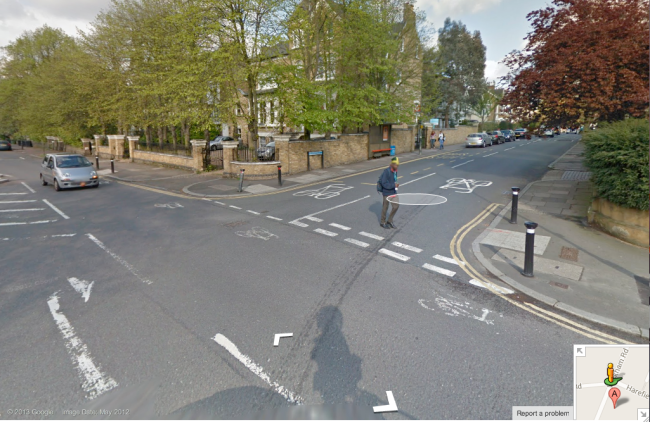
Firstly, the side road junction. This one used to give me grief every day when I lived nearby.Image

Priority is for drivers, cyclists and pedestrians on the main road which runs approximately north-south. In practice however, the majority of drivers turning left or right into the side-road (heading east, in the direction of this photo, as the car is about to do) will assume priority over a pedestrian who is going straight on along the pavement of the main road, crossing the side road (as this pedestrian is doing.) This is such common practice that the majority of pedestrians stop and give way to cars about to turn in or out of side roads. (If you’re in doubt about the priority of pedestrians at side roads, the wording is slightly vague, but look at the highway code here:  “watch out for pedestrians crossing a road into which you are turning. If they have started to cross they have priority, so give way.”) This ambiguity of priority is expressed in the road markings above, which do not indicate a pedestrian crossing, when in effect there could be a zebra crossing at every side road, as there are in many other countries. The above road markings are, however, design standards and can be found everywhere in the country, often with a smoother turning curves allowing cars to go into the side road at higher speeds than this one (for example here (picture.)) Newer street designs often raises the conflict area to the higher pavement level, beginning to rectify the situation, but unfortunately these humps are being implemented by certain local authorities in signal controlled junctions, leading to confusion and potentially causing serious accidents when there is a green signal for traffic to go straight on over the hump — for example here (street view.) This practice of drivers taking priority when turning into side roads makes walking in cities stressful and dangerous, and I believe encourages absent-minded drivers to ‘left hook’ cyclists, assuming that they will slow down for them when they turn in the same way that the vast majority of pedestrians do. I’m sure that this accounts for many accidents and highly off-putting near misses — for example in this terrifying video involving a police car:

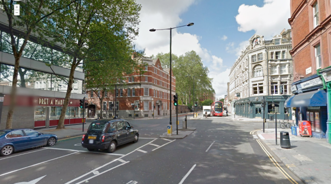
Secondly, the generic design for signalled junctions in the UK, where two busy roads meet. For example, this fairly busy junction in central London:

Image

In this instance, as with many, the signals follow a pattern of three different states: green lights for traffic coming from the west and east, green lights for traffic coming from north and south, and then green signals for pedestrians to cross all four crossings. Pedestrians are supposed to wait for their signal, which is often for less than 10 seconds after at least a minute’s wait, meaning that the majority of able-bodied pedestrians ignore their signals if possible and cross when there’s a gap in the traffic, a practice designed into the junction in the islands such as seen in this photo. This signalling allows road-users to turn left unhindered and to turn right subject to a gap in the oncoming traffic; any pedestrians in their way are breaching the highway code. This design of junction is explicitly discriminatory towards all pedestrians — making them wait for much longer than road users to walk along the road — but in particular those who cannot walk quickly, are at risk of stumbling or have disabilities such as being sight-impaired, who generally take precaution to wait for their signal.

From these examples, we can deduce a legally-imposed culture of driver hierarchy over more vulnerable road-users. According to research, 75% of accidents involving cyclists occur at junctions,* and I’d expect a similar figure for pedestrian accidents. I believe that the culture of drivers assuming priority when turning — both at side-roads and junctions — is single-handedly responsible for this situation. It is easy to predict a vehicle or pedestrian’s movement when you can be confident they are going to continue in the same direction, but when they could swing around to the left unhindered, accidents happen, both with pedestrians, and with cyclists, such as almost what almost happened in the above video, and what leads so many HGVs to kill cyclists in London.

[* Department for Transport, Reported Road Casualties Great Britain 2012, table 20006 cited here]

This culture is also of course also a huge barrier to the provision of segregated cycling facilities, both at side-road junctions and at major junctions. The few examples of clearly retained cyclist priority still look dangerous in a British context, where drivers are not used to giving priority in this sort of situation: (source)

There needs to be a structural change in the design of all junctions in the country that give express priority to pedestrians and cyclists to the side of traffic when the vulnerable road-users are going straight-on. Theoretically, we need to begin to remove this fundamental, geometric hierarchy of road users. Most simply, this could take the form of sharper angles at junctions (sharper than in the above photo), humped zebra crossings and signs reminding drivers to yield (also absent above.) I have not written about roundabouts, but as in the Netherlands, I would argue that they should also have zebra crossings at each entry/exit at which drivers yield to cyclists, or else they should be grade separated. At the moment, this ideological hierarchy is unfair, unsafe and contributes greatly to wider culture of car-dependency.

N.B. In many urban areas there are many one-way systems which mean that the major flows of traffic are not always straight on. In general terms I would argue that these need to be removed and roads returned to more linear forms before straight-on priority for pedestrians and cyclists can be implemented in such cases. Theoretically, the absence of street-planning in the development of towns and cities in Britain does mean that primary traffic flows don’t always follow a grid-like typology — this is most likely the biggest caveat in my argument. Thus, it might be argued that Britain has always thrived from avoiding planning, and that imposing right-angles into every historic junction would be doing an injustice to the natural, historic flows of the roads, for example where two main roads meet and flow into one (e.g. where Queens Road (A202) and Old Kent Road (A2) merge into New Cross Road (A2) in inner London). I would argue that this assertion is mythologising, and that planning always happens to an extent but that there is always a compromise. It is a matter of practicality that in order to move people from cars to cycling on segregated facilities, it is necessary to redesign junctions to follow a right-angled typology or roundabouts (with cyclist/pedestrian priority) as part of a wider ideological shift towards local connectivity, and on a related theoretical point, to strive towards greater linear connectivity across barriers for non-motorised traffic and less enclosure e.g. more small bridges over railway lines, motorways and rivers, fewer and smaller private enclaves.